Electrical Resistivity Tomography
Electrical Resistivity Tomography (ERT) is a widely used geophysical method to non-invasively infer the spatial distribution of electrical resistivity in the subsurface. The method proceeds by sequentially driving electric current between electrode pairs and measuring the produced voltages at other electrode pairs. Using hundreds of such data, the inverse problem is solved leading to a resistivity distribution (of a discretized subsurface) that honors the measured data.
The electrical resistivity (or its inverse, conductivity) is highly influenced by soil attributes (e.g. porosity, water content, clay content) and these relationships have been widely studied. Presently, ERT surveys are used routinely in soil studies. For example, in the particular case of soil compaction, the immediate effect of compacting the soil will be an increase in saturation and volumetric clay content, such changes are expected to decrease the electrical resistivity of the soil. Soil compaction is, thus, expected to have a clear electrical signature that can be captured by the ERT method.
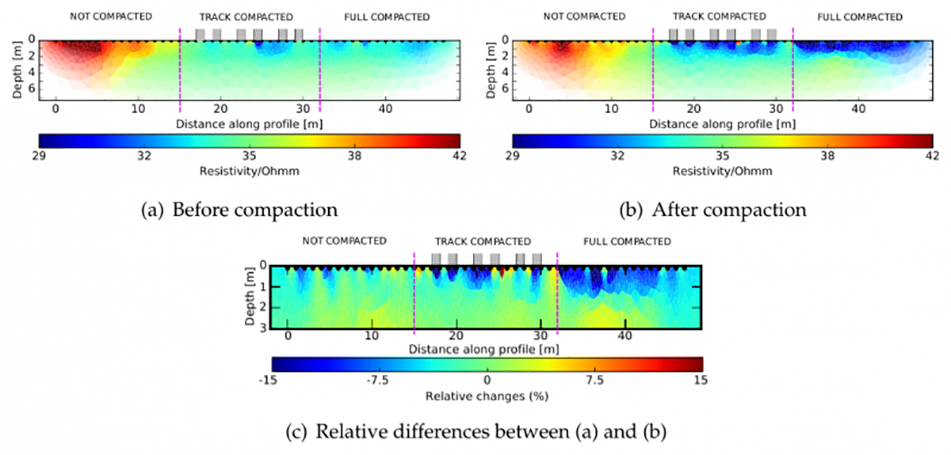
Electrical resistivity inverted from ERT measurements in Block B and Bare Soil before compaction (a) and after compaction (b). As up to 15% impact is observed in the soil resistivity (c) in response to the compaction event.
This effect was observed at the SSO, in figure 1(c) we show the relative difference between the estimated electrical resistivity on 21 March 2014 (1(a), before the compaction) and April 2014 (1(b), 12 d after compaction). The soil electrical resistivity decreased by 10 to 15% for the part of the block that had undergone compaction. These results were obtained by an inversion process that smoothens actual variations in resistivity, which implies that the compaction-affected depth range is probably smaller than the approximately 0 to 1 m that is indicated in this figure.