Mocoa event 2017
The new STEP-TRAMM landslide and debris flows model applied to the Mocoa event (31st March 2017), Colombia – STEP TRAMM
Jonas von Ruette, Peter Lehmann and Dani Or
An extended article about the Mocoa and Sierra Leone 2017 event has been published on external pageEOS.org (27th of August 2018)
STEP-TRAMM project files of the case studies of Mocoa and Sierra Leone:
Important: these files and simulation results using STEP TRAMM software should be interpreted with care. The model works under several assumptions and simplifications. Additionally, data quality and resolution used (DEM, rainfall, …) also influence the model’s outcome.
On the night of 31st of March 2017, heavy rainfalls triggered a series of landslides in the area of the city of Mocoa, Colombia. Based on measurements of the satellite mission “Global Precipitation Measurement” from NASA and the Japan Aerospace Exploration Agency more than 80 mm of rainfall occurred from March 26 to April 2. According to an article by external pageMongabay the Colombian Institute of Hydrology, Meteorology and Environmental Studies (external pageIDEAM) up to 129.3 mm of rainfall was measured in the area around Mocoa during a period of only three hours. In this area these rainfall amounts are usual but are normally rainfall sums distributed over a period of ten days. In the night of the 31st of March probably a wide range of landslides were triggered in the hillslopes of the catchments of the river Taruca, Conejo, Sangoyaco, Mulato and Mocoa which reached the river beds (article in external pageSemana Sostenible). With ongoing rainfall and increasing river discharge the landslide deposits were remobilized as debris flows eventually leaving the narrow channels in the catchments and expanding on to the flood plains and reaching the village of Mocoa causing extended damage to buildings, roads and more than 250 people died during the event.
It became clear that existing landslides have been filling up the river beds and the potential of such an event has been recognized but sadly did not provide an initiate for measure by the respective authorities even though articles were published in the local newspapers (external pageJorge Kuaran, Notifronteras).
The Soil and Terrestrial Environmental Physics (STEP) research group at ETH Zurich recently developed a landslide triggering software STEP TRAMM which is a result of several PhD projects and interdisciplinary research project “Triggered Rapid Mass Movements” (external pageTRAMM). This landslide triggering model is capable to simulate the triggering of shallow landslides at the catchment scale using threshold-based soil mechanic distribution rules resulting in highly localized landslide patterns. The cool thing about this software is that it can be applied anywhere on Earth, based on readily available DEM, forest cover, soil type and precipitation data. We have taken the SRTM DEM model with a 30 m spatial resolution as the basis for landslide simulations of the catchments near Mocoa. The STEP TRAMM software includes a soil depth evolution algorithm to assess soil depth distribution for the study area in case there is now limited information shown in Fig. 1.
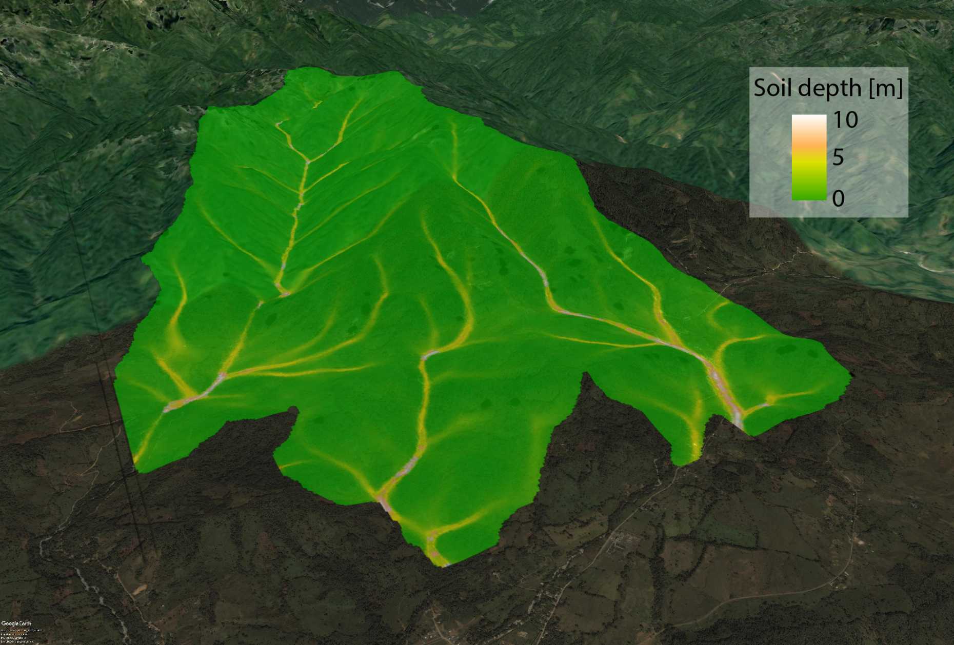
Fig. 1: Soildepth distribution for the study area computed by the soil depth module of the STEP-TRAMM software.
Besides the 30m DEM, the project external pagesoil-grids.org allowed us to define clay loam as the prominent soil type for the study area. The presence of tree roots has a significant influence on slope stability acting as anchors and reinforcing the soil mantle. We used the external pageGlobal Forest Change Database from the University of Maryland to describe the distribution of forest cover in the study area.
First results of the STEP TRAMM software already provided some interesting insights on landslide occurrence at the foothills of the city Mocoa and in the catchment of Taruca river. All landslides occurred on the steep hillslope sections close to the ridge of the catchment and commonly in sections with no forest cover. The impact of deforestation on soil degradation as well as landslide occurrence has been discussed in this area and with this recent event the discussion of deforestation and land management has gained new interest (external pageMongabay).
The STEP TRAMM simulation resulted in a total of 56 triggered landslides with a range in landslide volume of over 8’000 m3 (smallest volume 57 m3 and largest of 8400 m3). Figure 2 shows the overview of the city of Mocoa with the catchments in the West where with the simulation domain of STEP TRAMM showing the runout hazard of the simulated landslides.
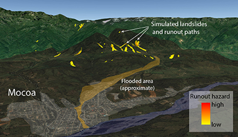
Fig. 2: Overview of the city of Mocoa and the mountain range in the vicinity of the city. The flooded are in light brown shows approximately the extend of the flood event which came from the catchment of the river Taruca. In the background the potential runout paths of simulated landslides are shown for the rainfall event of 31st of March 2017. The simulations shows how the triggered landslides reach the river beds providing the material for the debris flow event causing large destruction in Mocoa.
Figure 3 shows a close up of the foot hills and the Taruca catchment with landslides from the 2017 event and on the right side simulated landslides (in red) with the respective runout hazard
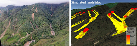
Fig. 3: In the left image aerial view of the Taruca catchment (via external pageMongabay and Corpoamazonia) and the landslide triggered in the March 2017 event. On the left oblique view in Google Earth for the same catchment section with the simulated landslides (red polygons) and the respective runout hazard.
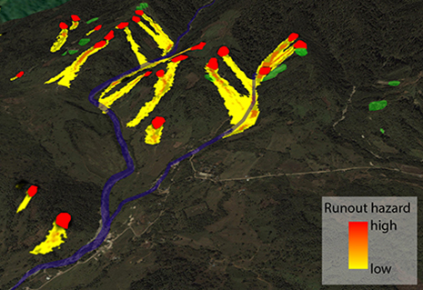
Fig. 4: Oblique Google Earth view of the catchment of the Taruca river with old landslides (mapped with Google Earth imagery) shown with green polygons. Simulated landslide runout indicates the STEP TRAMM software shows that the landslide can potentially reach the river beds which probably contributed to the severity of this event.
Considering the limitations of a relatively coarse DEM (30 m), limited data of soil type and properties, initial conditions and detailed rainfall information the STEP TRAMM software was able to provide detailed information of landslide patterns, location and volume which do resemble to landslide which have occurred in previous events. It also indicates that the role of deforestation plays an essential role on landslide triggering conditions and occurrence. Finally, the landslide runout module of the software showed that the runout hazard of simulated landslide can reach the river channels, thereby increasing the probability of massive debris flow events with catastrophic consequences how we sadly have observed and read in the case of the city of Mocoa.